
How to Find Your Property Lines the Right Way
 Knowing where your property lines are matters more than most people realize until something goes wrong. A planned addition gets too close to the edge. A new neighbor puts up a shed that seems to be on your land. A contractor asks where the lot ends before they start digging.
The good news is there are several ways to get a picture of your property lines. The important thing is knowing what each method actually shows and where it stops being reliable.
Start With Your Deed
Your property deed is the legal document that describes your land. It contains a written description of the boundary, sometimes using directions and distances, and sometimes referring to a recorded plat map.
If your deed references a plat, that plat is recorded at the Tuscaloosa County Probate Office and is part of the public record. The plat shows your lot in relation to neighboring lots, streets, and any easements on the property.
Reading a deed description takes some practice. The language can be old-fashioned or technical. But it is the starting point for any serious effort to understand where your property sits.
Check the Tuscaloosa County Probate Records
The Tuscaloosa County Probate Office holds recorded plat maps, subdivision maps, and deed documents for properties throughout the county. These records are public, which means any property owner can request them.
A recorded plat map shows lot dimensions, lot numbers, street layouts, and in many cases the location of easements. It gives you a clear picture of how your lot was originally laid out when the subdivision was created.
Keep in mind that plat maps show planned dimensions, not necessarily what is on the ground today. Corners can be displaced, lots can be re-described, and older plats may not reflect changes made over the years.
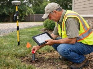
Look for Physical Property Markers on Your Land
When a property is surveyed, the surveyor sets physical markers called monuments or pins at the corners. These are usually iron rods or pipes driven into the ground, sometimes with a plastic cap stamped with the surveyor’s license number.
Finding these pins is one of the most reliable ways to locate a property corner. Here is how to look for them:
- Check the corners of your lot first. Pins are usually set at each corner of the property.
- Use a metal detector. Pins are iron and can be detected even when buried under soil, mulch, or grass.
- Look at the base of old fence posts. Fences are sometimes installed along property lines, and a pin may be nearby.
- Check around utility boxes or survey caps. In some subdivisions, permanent concrete monuments are set at key corners.
Be aware that pins can be moved, buried, or removed over time. Finding a pin gives you a strong lead, but a displaced pin can also send you in the wrong direction.
Use the County’s Online Parcel Viewer
Tuscaloosa County, like most Alabama counties, has an online parcel viewer that lets you search for properties by address and see an aerial map with approximate property boundaries overlaid.
This tool is useful for getting a general sense of where your lot sits in relation to streets and neighboring properties. It is free and easy to use.
However, it has real limits. The boundaries shown are based on deed records and are drawn to give a rough picture. They are not field-verified and are not accurate enough to make decisions about construction, fencing, or boundary disputes. The parcel viewer is a starting point, not a final answer.
Review a Previous Survey if One Exists
If your property was surveyed in the past, a copy of that survey may be in your closing documents, with your title company, or on file at the Tuscaloosa County Probate Office.
A previous survey gives you the most detailed picture of your property lines outside of getting a new one done. It shows measured distances, corner locations, and any encroachments or easements noted at the time.
Check whether the survey is recent and whether anything has changed since it was done. If the previous survey is more than ten or fifteen years old, or if there has been construction, a sale, or any deed changes since then, the information may be incomplete.
When the Above Methods Are Not Enough
Each of the methods above has value. Together they can give you a reasonable picture of your property. But none of them produce a legally recognized boundary determination.
There are situations where you need more than a general picture:
- You are planning to build a structure and need to confirm setback compliance
- A neighbor is disputing where your line is
- You are selling your property and a buyer wants confirmed boundaries
- You found a pin but are not sure it is in the right place
- Your deed description is old, vague, or conflicting with a neighboring deed
In these situations, the only reliable next step is a survey by a licensed Professional Land Surveyor. They combine the deed research, field measurements, and legal expertise needed to give you a certified, defensible answer.
Understanding Property Line Markers You May See in the Field
When you are walking your lot, you may come across different types of markers. Here is what they typically mean:
- Iron rod or pipe. The most common type of property is a corner monument set by surveyors. Usually half an inch to one inch in diameter.
- Concrete monument. A larger, more permanent marker sometimes set at subdivision corners or along road rights-of-way.
- Plastic cap on a rod. The cap is usually stamped with the surveyor’s name or license number. This identifies who set the corner and when.
- Wooden stake with flagging. Temporary markers used during active survey work or construction staking. These are not permanent monuments.
- Painted marks on pavement or curb. Usually indicate utilities or temporary reference points, not property corners.
If you find a marker that looks like a property corner but you are not sure it is in the right place, do not move it. A surveyor can evaluate it and confirm whether it is a valid monument.