
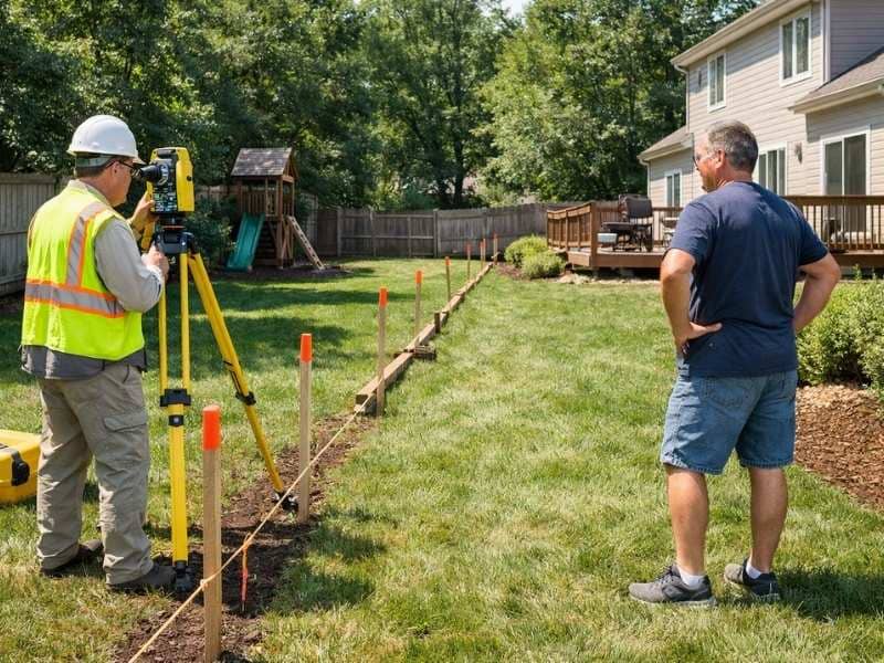
Property line problems don’t come with a warning. One week you’re planning a backyard project, and the next you’re in a tense conversation with a neighbor about two feet of land. Boundary surveys are what keep that from happening. A boundary survey is an official measurement of your property lines done by a licensed surveyor. They look at legal records, old documents, and the land itself to find exactly where your property begins and ends. That result has legal weight, and it answers questions before they turn into arguments.
Why Visible Features Do Not Always Match Legal Property Boundaries
Fences, driveways, tree lines, and landscaping are not legal proof of where a property line sits. They show where a past owner thought the line was, not where it actually is. Only a licensed survey sets the legal boundary.
That fence you’ve been trimming around for years was probably put up without any professional measurement. Someone guessed, or made an informal deal with a neighbor at the time. Neither of those things holds up legally, and neither does the fence.
Driveways cause the same issue. A paved surface that curves slightly onto the next property can stay that way for decades before anyone notices. When the land changes hands, the new owner finds out they’ve been using someone else’s land the whole time.
What looks settled on the ground can be completely wrong on paper. A licensed surveyor checks deeds, plat maps, recorded easements, and physical markers to find the real line. That’s a different process from trusting where someone once put a fence post.
How Boundary Surveys Help Catch Encroachments Early
A boundary survey finds structures like sheds, retaining walls, fences, and driveways that cross a property line. Finding these early gives both owners more options and fewer legal headaches.
When an encroachment is found early, neighbors can usually work it out. One person moves a structure, or both sign a written agreement. The problem gets handled before it picks up any legal history.
An encroachment is when something sits on land it has no legal right to be on. A shed built six inches past the line. A retaining wall that drifts onto the next parcel. A driveway that widens near the garage and crosses the boundary without anyone catching it. These are more common than most people expect.
Wait several years, and the choices get harder. Long-standing encroachments can lead to adverse possession claims. That’s a legal concept where someone argues they’ve used a strip of land long enough to have a right to it. In most states, that clock runs between five and twenty-one years. A survey stops the problem before that becomes a concern.
Why Property Improvements Should Start With Boundary Verification
Knowing where your property lines are before you build prevents expensive mistakes. A pool, garage, addition, or patio built across a property line may need to be torn down or moved at your cost.
Contractors don’t check your boundary before they break ground. That’s the owner’s responsibility. So if a project is planned based on a rough idea of where the property ends, the owner carries the risk.
If a finished structure sits three feet into a neighbor’s yard, the fixes are painful. Move it, negotiate, or go to court. None of those are cheap, and all of them were avoidable.
This applies to anything permanent near a boundary: pools, garages, additions, retaining walls, large landscaping work. Anything that needs a permit. Checking the boundary first is the straightforward way to protect what you’re building.
How Accurate Boundary Information Supports Better Neighbor Relations
When neighbors work from the same verified boundary information, they can talk through questions before those questions become disputes.
Most property line conflicts aren’t really about the line. They’re about one person feeling like another is taking something that isn’t theirs. That’s hard to resolve when each side is using different information.
A survey changes the conversation. Both owners look at the same document and see the same line. There’s no “my grandfather said it was the oak tree” against “our deed says otherwise.” The documented boundary removes the guesswork.
That shared information also makes practical cooperation easier. Two neighbors splitting the cost of a new fence need to agree on where it goes. Shared drainage work, tree removal near the line, access agreements — all of these go more smoothly when both sides trust the same boundary document.
Why Boundary Surveys Can Prevent Surprises During Future Property Transactions
Clear, documented property boundaries reduce uncertainty for buyers, sellers, and lenders. Boundary questions that come up during closing can delay a sale or cause it to fall through.
Real estate transactions already have a lot of moving parts. A boundary problem at the closing table needs to be resolved, not just noted. That takes time nobody has at that stage.
Sellers who get a survey before listing remove one big unknown from the process. Buyers can look at the survey, confirm what land is included, and move forward without open questions. Lenders and title companies raise fewer concerns when the boundary is already documented.
Buyers who skip the survey take on real risk. The property may include less land than expected. An encroachment may transfer with the deed. A neighbor may have a valid claim to part of the yard. According to the American Land Title Association, boundary disputes are among the most common categories of title claims filed each year. A survey done before closing gives everyone at the table the information they need.
Frequently Asked Questions About Boundary Surveys
What is the purpose of a boundary survey?
A boundary survey establishes the legal location of property lines. A licensed surveyor researches deeds, plat maps, and recorded documents, then measures the property on-site. The result is a documented, legally recognized description of where the property edges are.
Can a boundary survey help prevent property line disputes?
Yes. When both property owners have the same accurate boundary information, disagreements are easier to resolve and less likely to grow. Disputes often start because each side is working from different assumptions. A survey replaces those assumptions with documented facts.
Should I get a boundary survey before building a fence or addition?
Yes. Structures built across a property line may need to be moved or removed at the builder’s expense. Confirming the boundary before construction is the most reliable way to make sure improvements are placed on the right parcel.
Can a boundary survey reveal encroachments?
Yes. A boundary survey can identify fences, sheds, retaining walls, driveways, and other improvements that cross a property line in either direction. Finding these before a sale or construction project gives owners the best chance to address them.
When should a property owner consider getting a boundary survey?
Common situations include before starting construction, before buying or selling property, when inheriting land that hasn’t been recently surveyed, when there’s a disagreement with a neighbor about boundary location, and before subdividing a parcel. Addressing boundary questions early is almost always less complicated than dealing with them after a problem develops.