
Boundary Survey Cost: What You Pay and What You Get
 Most people ask about the price of a boundary survey before they know what one actually does. That is completely normal. But once you understand what you are getting, the cost starts to make a lot more sense.
What a Boundary Survey Gives You
A boundary survey is a legal map of your property lines. It shows exactly where your land starts and stops. The surveyor uses your deed, the county’s records, and measurements taken on your property to create this map.
When the job is done, you receive a document that includes:
- The exact location of each property corner, marked with a pin or monument in the ground
- The length and direction of each boundary line
- Any encroachments found, such as a neighbor’s fence that crosses into your property
- Easements on the property, such as a utility line or shared driveway path
- The surveyor’s official seal and signature
That seal is what makes it legal. Without it, the document cannot be used for permits, property transfers, or anything involving the courts.
When Do You Actually Need One?
Not every situation requires a boundary survey. Here are the most common times when one is necessary.
Before You Build a Fence or Add a Structure
If you plan to put up a fence, build a garage, or add anything near your property line, you need to know exactly where that line is. Building even a few inches onto a neighbor’s property can mean tearing it down and paying legal fees. A boundary survey removes the guesswork.
When You Are Buying Raw Land
Buying an empty lot or a piece of land is different from buying a house. Most undeveloped properties do not come with a recent survey. Getting one before you close tells you exactly what you are paying for and whether the land matches what the deed says.
When You and a Neighbor Disagree on a Property Line
Fence disputes and boundary disagreements between neighbors happen all the time. A boundary survey gives you a clear, certified answer. In many cases, having that document in hand is enough to settle the issue without going to court.
When You Apply for a Building Permit
Tuscaloosa County requires you to show that your planned structure meets setback rules. A setback is the minimum distance a building must sit from the property line. A boundary survey tells the permit office exactly where your lines are so setbacks can be checked and approved.
When You Want to Split Your Property
If you want to divide one piece of land into two or more lots, the process starts with a boundary survey. It confirms your existing lines before a new subdivision plat can be drawn and filed with the county.
What Does the Surveyor Actually Do?
A boundary survey is not just someone walking around your yard. Most of the work happens before the surveyor ever shows up at your property.
Step 1. Research
The surveyor goes to the courthouse first. They pull your deed, check the recorded plat map, and look at the deeds of nearby properties to see if there are any conflicts. In Tuscaloosa County, some rural properties have deed descriptions that are decades old. Reading and making sense of those takes real time and skill.
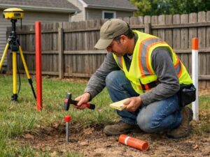
Step 2. Field Work
Once the research is done, the surveyor comes to your property. They use GPS equipment and other precision tools to find existing corner pins, measure the boundary lines, and note anything on the ground that affects the boundary, such as a fence or wall.
If corner pins are missing, the surveyor calculates where they should be based on the deed and places new ones.
Step 3. Office Work
Back at the office, the surveyor draws the final plat, runs quality checks, and notes any difference between what the deed says and what was found in the field. Then they sign and seal the document. That is when it becomes an official legal record.
What Makes the Price Go Up or Down?
Some boundary surveys cost more than others. Here is what pushes the price higher:
- Old or unclear deed descriptions that take more time to research and interpret
- Missing corner pins that have to be re-calculated and reset
- Conflicting deed records between your property and a neighbor’s property
- Waterfront lots along the Black Warrior River, where the natural boundary can shift over time
- Large parcels with more corners and longer lines to measure
On the other hand, a standard subdivision lot with a clean recorded plat and all corner pins still in place is one of the simpler and less expensive jobs a surveyor can take on.
A Boundary Survey Is Not the Same as a Parcel Map
Some homeowners try to find their property lines using county tax maps or online parcel viewers. These tools can give you a rough idea of where your property sits, but they are not surveys. They are not legally certified and they are not always accurate. They cannot be used for permits, insurance, or legal matters.
Only a boundary survey signed and sealed by a licensed land surveyor gives you a legally recognized answer.
Frequently Asked Questions
What is the difference between a boundary survey and a location survey?
A boundary survey finds and sets the legal corners of your property. A location survey, sometimes called a mortgage survey, just shows where existing structures sit on the lot. It is less detailed and cannot be used to resolve a boundary dispute or set property corners.
Do I need a new boundary survey if one was done ten years ago?
Not always. If the corner pins are still in place and nothing about the property has changed, an older survey may still work for many purposes. But if pins are missing, the deed was updated, or you need a new permit, it is usually safer to get a fresh one.
Will the survey show if my neighbor’s fence is on my property?
Yes. If anything crosses your boundary line, the boundary survey will show it. The survey does not resolve the situation for you, but it gives you a clear, certified record of what is actually there.
Can a boundary survey be used in an Alabama court?
Yes. A survey signed and sealed by a licensed Professional Land Surveyor is accepted as evidence in Alabama courts. It is one of the most reliable ways to resolve a property line dispute.
Does a boundary survey get filed with Tuscaloosa County?
Sometimes. Certain surveys in Alabama are recorded with the county probate office and become part of the public record. Others stay with the property owner. Ask your surveyor before the work begins so you know what to expect.