
Why a Topographic Survey Matters
 Most people think about property lines when they hear the word survey. But before building starts on most projects, there is another type of survey that builders, engineers, and developers depend on just as much.
A topographic survey does not look at where your property ends. It looks at what the land itself looks like. That information drives almost every decision made during the planning and building process.
What a Topographic Survey Shows
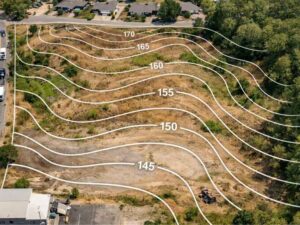
A topographic survey maps the physical shape of a piece of land. It records every rise, slope, dip, and flat area across the site.
The main result is a contour map. Contour lines connect points that sit at the same height. When the lines are close together, the ground is steep. When they are far apart, the ground is fairly flat. Builders and engineers read these lines the same way most people read a road map.
Beyond elevation, a topographic survey also records:
- Existing structures on the site, such as buildings, walls, and old foundations
- Trees and vegetation including tree lines and large individual trees
- Water features such as creeks, drainage ditches, ponds, and low spots that collect water
- Above-ground utilities such as power lines, utility poles, and pipes
- Roads and driveways on or next to the property
- Fences and retaining walls that affect how the land drains or is used
All of this is recorded with precise height measurements and drawn onto a scaled map that the whole project team uses throughout the job.
Why It Matters Before You Build
Land is rarely flat. A lot that looks level from the street may slope sharply toward the back, have a low spot in the middle that holds water, or have a small ridge that blocks drainage.
A topographic survey shows all of that before anyone starts digging.
Grading and Drainage
One of the biggest uses of a topographic survey is planning how the site will be graded. Grading means shaping the land so that water flows away from buildings and toward the right drainage outlets.
Without accurate height data, a grading plan is just a guess. A bad guess can result in water sitting against a foundation, flooding a crawl space, or draining onto a neighbor’s property. In Tuscaloosa, where heavy rain is common and many properties sit near creeks, getting drainage right at the start is important.
Foundation Planning
The shape of the ground affects how a foundation is built and what it costs. A sloped site may need a stepped foundation, retaining walls, or more excavation than a flat one. None of that can be planned or priced without knowing the exact heights across the site.
Engineers and architects need this data to decide where to place the building, how to orient it on the lot, and what type of foundation fits the terrain.
Utility Planning
Sewer lines and stormwater pipes run on gravity. That means they depend on slope. The engineer needs to know the height at every connection point to design a system that flows the right way. A topographic survey gives them those numbers. Without it, utility design is based on guesses that often turn out to be wrong once the work begins.
Permit Applications in Tuscaloosa County
Many building projects in Tuscaloosa County require a grading plan as part of the permit application. A grading plan cannot be made without a topographic survey as its starting point. Sending in a permit application without accurate height data often leads to rejection or delays while extra information is gathered.
Who Needs a Topographic Survey
Topographic surveys are not only for big commercial jobs. Here are the most common situations where one is needed in Tuscaloosa:
- Homeowners building on a vacant lot, especially one with any noticeable slope
- Developers planning a subdivision who need to understand drainage and road grading across the whole site
- Contractors doing site work such as grading, excavation, or utility installation
- Engineers designing drainage systems for homes or commercial buildings
- Architects designing a structure where the relationship between the building and the land matters
- Property owners near waterways who want to know how water moves across their land in heavy rain
If your project involves moving earth, adding pavement or concrete, or placing a structure on land with any visible change in height, a topographic survey should be part of your plan.
How a Topographic Survey Is Done
The field crew visits the site and takes height measurements at regular points across the whole area. They use GPS equipment and total stations to get precise readings at hundreds or even thousands of points, depending on the size of the site.
They also find and record all the physical features listed above: buildings, trees, utilities, water features, and more. Each feature is tied to a specific height so that its position on the finished map is accurate.
Back at the office, the data is processed and the topographic map is drawn. Contour lines are created from the height measurements, and all the features are placed in their correct spots. The licensed surveyor checks the finished drawing, then signs and seals it.
The final map gives the whole design team an accurate picture of the site to build from.
What Goes Wrong Without One
Skipping a topographic survey is one of the most common reasons building projects go over budget or fall behind schedule.
The problems that come up most often are:
- Surprise excavation costs when the site turns out to be steeper or rockier than expected
- Drainage problems where water collects against a foundation or runs onto a neighbor’s land
- Permit delays when the grading plan does not match what is actually on the ground
- Design changes mid-build when the engineer finds the site does not match what they assumed
- Unplanned retaining walls when the slope needs more structural support than was budgeted
Every one of these problems costs more to fix after building has started than a topographic survey would have cost before it began.